24/7 Threat Detection for Government

24/7 Threat Detection for Government
The DataCapable® Platform™ understands the severity of threats in minutes and enables real-time, integrated responses to help all levels of government agencies prepare, mitigate incident impact, and accelerate recovery.
24/7 Threat Detection for Government

A Trusted Partner for Community Safety

In the early minutes of an emergency event or threat, having access to human-verified intelligence you trust can make all the difference in the effectiveness and quality of your response. By deploying the right resources when and where they’re needed most, you can bring events under control sooner, mitigate further spread, and reduce impact to your constituents and their critical assets.
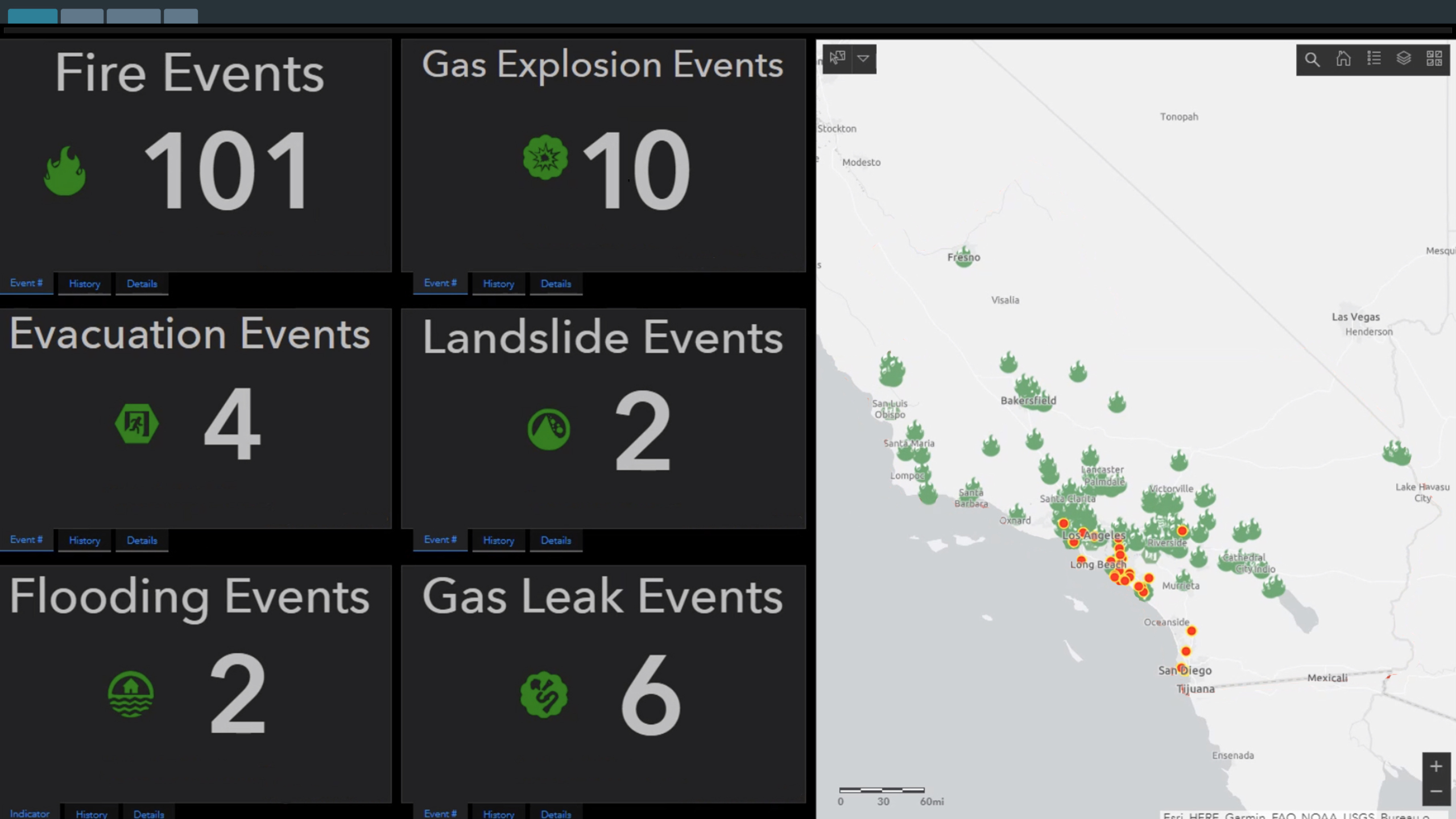
  • Real-time discovery keeps you informed when events impact people and places in your jurisdiction.
  • Event notifications make it easy to share critical information with key stakeholders.
  • Patented algorithms and 24/7 human-in-the-loop validation reduce noise that prevents the exchange of critical information while simultaneously reducing operational overhead.
  • Seamlessly integrate your existing technology and workflows through the DataCapable® Platform™ software.

Geo-locate Threat Activity

Geo-locate Threat Activity
1
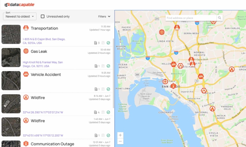
  • Know the scale and location of emergencies and threats in minutes. Confidently target responses with pinpoint mapping.
  • The cloud-based DataCapable Platform stays up if internal systems fail. Stay in touch with events on the ground even during power outages.

Improve Efficiencies

Improve Efficiencies
2
  • Trained analysts validate incidents so you can trust the intelligence and block out noise.
  • The DataCapable Platform can be right-sized to suit your budgetary guidelines with a variety of service packages.
  • Seamless integration with existing technologies via our API; no further technology investments required.

Advanced Reporting

Advanced Reporting
3
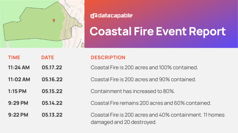
  • The DataCapable Platform provides historical data exports. Meet post-event reporting requirements faster.
  • Easily share reporting with stakeholders. Spend less time compiling data and more time managing your department and resources.
  • Private and secure – no PII (personal identifiable information) is stored on our servers, alleviating privacy concerns.
Geo-locate Threat Activity
1
Improve Efficiencies
2
Advanced Reporting
3

Key Benefits for Government Emergency Managers

<p><strong>Budget friendly:</strong> A variety of service packages can accommodate budgetary constraints. Access untapped productivity with fewer resources.</p>

Budget friendly: A variety of service packages can accommodate budgetary constraints. Access untapped productivity with fewer resources.

<p><strong>Trained analysts:</strong> Human-in-the-loop analysis validates data flows so your team can target responses with confidence.</p>

Trained analysts: Human-in-the-loop analysis validates data flows so your team can target responses with confidence.

<p><strong>Interoperability:</strong> Seamlessly integrates with your existing apps and technologies via our API; no further technology investments required.</p>

Interoperability: Seamlessly integrates with your existing apps and technologies via our API; no further technology investments required.

<p><strong>Accuracy:</strong> Know the impact and location of emergencies and threats in minutes. Target responses via advanced pinpoint mapping.</p>

Accuracy: Know the impact and location of emergencies and threats in minutes. Target responses via advanced pinpoint mapping.

<p><strong>24/7 threat monitoring:</strong> Reduce the burden of threat monitoring on your employees. The DataCapable Platform is your eyes and ears in the field.</p>

24/7 threat monitoring: Reduce the burden of threat monitoring on your employees. The DataCapable Platform is your eyes and ears in the field.

<p><strong>Peace of mind:</strong> Maximize productivity and applied resources by choosing a partner who is vested in the safety of your constituents.</p>

Peace of mind: Maximize productivity and applied resources by choosing a partner who is vested in the safety of your constituents.

Insights

  • Tornado Alley Is Shifting. How Does That Impact You This Storm Season?

  • Looking Ahead: How GIS Will Impact Operational Resiliency in 2023

  • DataCapable, Inc. is Named a Top 100 Geospatial Company for 2023

  • DataCapable, Inc. Named a Top 100 Geospatial Company

  • MMM Tech Law: SE Tech Video Series Featuring Pete DiSalvo, Co-Founder and CEO of DataCapable

  • Spotlight Series – Andrew Darney-Lane

  • Webinar Recap | Eye of the Storm: Outage Data During a Superstorm

  • Case Study: Leveraging Outage Data to Stay Ahead of Hurricane Season

See All

Request a Demo

Request a Demo